Tag Archives: cmu

Bridges of Pittsburgh – never the same bridge twice

9 Nov

This is a fun CMU affiliated project that attempts to “discover how many of Pittsburgh’s 446 bridges can be traversed without crossing the same bridge twice.”

From the organizers:

In 1736, mathematician Leonard Euler proved it was impossible to walk through the German city of Königsberg crossing each of the city’s seven bridges exactly once. His work, famously dubbed the “Bridges of Königsberg” problem, laid the foundation for graph theory and network analysis, and foreshadowed the invention of topology. We intend to create an expanded, more complex version of this famous study using Pittsburgh’s 446 bridges (Regan 2006).

Check it out here.

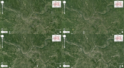
Amazing 30-year Timelapse of Satellite Photos

10 May

timelapse

Click to make BIG

Google, Carnegie Mellon, Time, and NASA just made a map geek’s wet dream come true.  They created a map where you can watch an animation of a 30 year time lapse – anywhere on earth.  They highlight some really dramatic scenes like the growth of Dubai, the melting glaciers, mountaintop removal sites, and the loss of rainforest. You can watch as Las Vegas’ sprawl devours the land and sucks a lake dry.

But, we have our own fairly interesting stories being told on this map, as our city changed significantly over the last 30 years. For instance, you can watch I-279N sprout out of the city, grow north, then blossom into the norther burbs.  You can also see Homestead go from steel mills, to brownfields, to sprawling shopping mall.  It’s quite fascinating, however scary it is.

There’s plenty of fun stuff to waste time looking at.

Say goodbye to your evening here: world.time.com/timelapse

Pac Tom Project

22 Apr

This is pretty mindblowing.  This guy, Tom, is trying to run every street (1031 miles) in the City of Pittsburgh and has logged the progress.

From the site:

Hi! Pac Tom is my project to run the length of every street in Pittsburgh. Check out the rules. It’s called Pac Tom because it’s like a very slow version of Pacman without the ghosts or power pills, and my name is Tom.

The above beautiful map is particularly interesting.

It shows the shortest route from Tom’s house from any place he’s been. The colors indicate the direction that he should be running on that segment to decrease the distance to his home. Green means East, red means North, violet means West, cyan means South.

The site is amusing and full of other graphs, maps, etc. And you can follow Tom’s project.

Click here to explore the genius that is Pac Tom