
Finally.
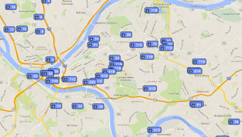
Port Authority releases a system wide map.
I really got nothing more to say, other than finally.
Also coming soon: real time data, that may or may not be better than Transit App.
Finally.
Port Authority releases a system wide map.
I really got nothing more to say, other than finally.
Also coming soon: real time data, that may or may not be better than Transit App.

Someone made a Google Map of every trolley line in the US that survived to the end of 1957.
Here’s a screencap of Pittsburgh.
In 1956, the Pa. General Assembly consolidated the companies by creating the Port Authority of Allegheny County, which transitioned from streetcars to buses, mainly to save money in operations and maintenance, per WESA.
Once there, you can click on a line for more info and abandonment dates.
Then you can cry.

Click to make BIG
From the annals of the newly formed, but now extinct, “Department of City Transit.” The actual name of the document is: Communication from the City Transit Commission of Pittsburgh to the Mayor and City Council, containing a Report on a plan for financing initial subway construction in Pittsburgh. This one is from March 1926, building upon a previous report from 1917.
The document goes on to describe the “diagrammatical representation of a future comprehensive rapid transit system for Pittsburgh and we recommend that the first rapid transit unit of this system to be completed should be the so-called Fifth Avenue line from the North Side to the East End.” The northern terminus would be “either at Ohio Street or at North Avenue. The eastern terminal “would probably be at Frankstown Avenue near Dallas Avenue.”
This line would follow Federal Street…and would pass under the Allegheny River through subaqueous tunnels….The line would follow Sixth Street to Liberty Avenue and thence pass under private property to Fifth Avenue on the remainder of its route throught the central business district and thence proceed through the through the Oakland District to Craig Street at Fifth Avenue. After passing under private property to Neville Street, it would follow Ellsworth Avenue to Devonshire Street and thence proceed, mostly under private property to Center Avenue west of Liberty Avenue. It would follow Center Avenue to Penn Avenue in East Liberty and thence follow Frankstown Avenue to a terminal near Dallas.
While fun to imagine what Pittsburgh would look like if this had happened, it mostly fills me with sadness. Nearly 100 years later, the best we can come up with to replicate this is Bus Rapid Transit, and only to Oakland. Bummer.
This is quite mesmerizing watching the buses slowly squirm across the screen like a plate of maggots. And would make a nice screensaver.
One step closer to convenience.

Click to make BIG
This is amazing. You can purchase a poster as well.

I’m a huge fan of the Pittsburgh Post-Gazette’s interactive maps (duh), but this one might be the best ones yet. It tracks the history of Pittsburgh’s numerous inclines over a vintage map, that were sadly torn down over the years. Fortunately, we still have our beloved Mon and Duquesne inclines, but it’s nice to imagine a time when people could take an incline directly to a street car and go and get their shoes repaired. On some of these inclines, people were allowed to even bring their horses on! Think of that the next time one of the operators gives you trouble for wanting to take your bicycle aboard.

Devastating Port Authority service cuts were announced that it would have to cut services by 35% by September 2. The above map shows the devastation.
Here’s another map that shows the ACCESS service cuts in pink. Thanks to the ACTC blog for that one.

How sad.
What are the chances that the following maps have anything to do with the current problems that we face and the unwillingness of the state to take this crisis seriously?
Hmmmmm Tom Corbett?
![]()
Here’s some more insight and the fact that we’re not alone.
![]()
Click on the map to see a huge pdf
The map that every transit user had, or at least could look in bus shelters and stations, wasn’t made by the Port Authority. Rather, the map was made by a transit enthusiast (read: expert) who took his own time to create this resource.

Pittsburgh Railways Trackmap that the PIttsburgh Electric Railway Club published in the early 1960’s. How sad. Found on Flickr user davidwilson1949’s photostream. There’s also a great set of vintage Pittsburgh transit photos.

