Tag Archives: public transportation

Pittsburgh’s Bus Bunching

2 Nov

bunching-1

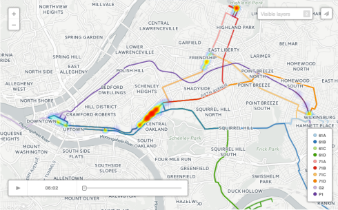
Bunching of bunches of buses.

Nobody wants that.

According to the creators:

Pittsburgh’s bunched buses bear the bad news of crowding (the front bus is often overfull, with subsequent buses nearly empty), excess waiting (bunching creates long waits between bus arrivals), and underutilization (crowding and unpredictable arrivals reduce public transit use). Caused by the cascading effect of variance in passenger arrivals, bunching bedevils public transit planners not just in Pittsburgh but in cities around the globe.

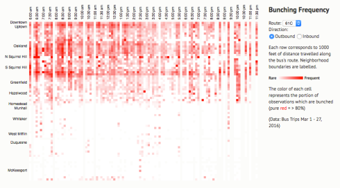
Does bunching follow predictable patterns? This project presents the geotemporal occurrence of bus bunching in Pittsburgh for PAAC routes 61, 71, P1 and G2 during March 2016.

bunching-2

See how them buses bunch

Real time bus tracking is here: pitlivebus.com

16 Oct

pitlivebus

This is quite mesmerizing watching the buses slowly squirm across the screen like a plate of maggots. And would make a nice screensaver.

One step closer to convenience.

http://pitlivebus.com

Sept 2: Pittsburgh’s Transit Doomsday, before and after

14 May

Click to make BIG

Devastating Port Authority service cuts were announced that it would have to cut services by 35% by September 2.  The above map shows the devastation.

Here’s another map that shows the ACCESS service cuts in pink. Thanks to the ACTC blog for that one.

Here’s some numbers taken from the same blog post (great post btw):
  • 46 of  Port Authority’s 102 routes will be eliminated
  • 40,000 rides will be lost, leaving thousands  of riders stranded
  • ACCESS coverage will be significantly reduced
  • 600 lost jobs
  • 18 park and rides will no longer be served
  • no service past 10 p.m. (with the exception of very few routes )

How sad.

What are the chances that the following maps have anything to do with the current problems that we face and the unwillingness of the state to take this crisis seriously?

Hmmmmm Tom Corbett?

Click to make BIG

Here’s some more insight and the fact that we’re not alone.

Time zone map of surface car lines

5 Jan

Click to make BIG.

A time zone map of public transportation surface car lines.  It reminds me of a phoenix.  The fire bird, not the city.

Thanks again to the wonderful Historic Pittsburgh site.