1897: Popular Bicycle Route No. 6 – Saxonburg, Freeport and Tarentum

13 Apr

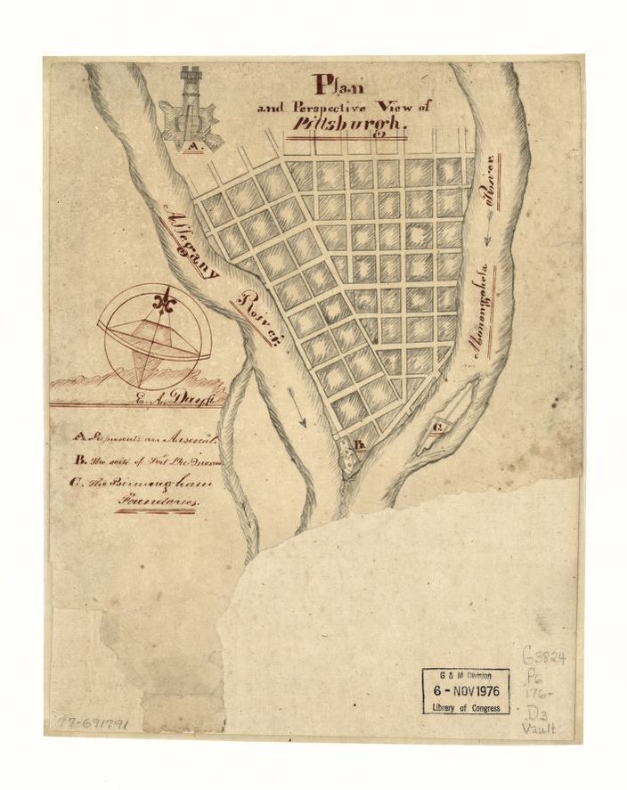
During the first bike boom of the 1890s, the Pittsburg(h) Press produced a weekly Sunday series of popular bicycle routes around Pittsburgh. All are accompanied by a map, some images, and a description that provides a delightful snapshot into the pre-auto era Pittsburgh.

This route takes riders on some roads that are still, to this day, popular road cycling routes in Allegheny County. Freeport Rd, Saxonburg – any Pittsburgh roadie is intimately familiar with this route. Even the description of the weather hasn’t changed all that much:

“The great amount of bad weather there has been this spring has kept the country roads in poor condition longer than usual, but all the roads described in connection with this run can be ridden now except on rainy days.”

Leave it to Pittsburgh to be swept up in the world bicycle boom only to have the weather put a damper on it.

Plume Pittsburgh

10 Mar

The Plume Pittsburgh site, a project of the Breathe Project, released a site that shows an animation for each day of where the pollution from the four biggest polluters in Allegheny County end up. Seeing the plumes juxtaposed with the SmellPGH reports is frightening, yet fascinating.

The animations, looking a bit like a 90s screensaver but of pollution, really help visualize the problem, probably better than anything I’ve seen to date. Watching the winds carry the pollution in these videos drives home the point that no one is safe. It’s particularly jarring when the winds are just right, to see them all converge, usually over Squirrel Hill.

The four sites, Clairton Coke Works, Irvin Works, Edgar Thomson Works, and the Cheswick Generating Station, are some of the worst polluters in the state.

To get the full experience of the animation, visit the Plume Pittsburgh site.

1979 Three Favorite Bike Trails, Pittsburgh Magazine

11 Sep

In 1979, people clearly didn’t know the difference between a bike trail and a bike route. Either way, this is a nice trip back in time to when Danny Chew, the million mile man and founder of the Dirty Dozen, was only 16 years old, and decided to quit riding his bike for the year when he hit 15,000 miles because he was afraid he’d “get bored.”

So many things in this article, in terms of Pittsburgh drivers, could have been written yesterday. Also, curious how different things could have gone if bicyclists in the 70s didn’t hate on bike infrastructure so much.

Thanks to the Pittsburgh History Pie twitter for digging up this map from a 1979 issue of Pittsburgh Magazine.


Map of a route through south west Pennsylvania from Fort Loudon, Franklin Co. to Fort Pitt, and the Ohio River to Fort Pitt Pittsburgh, 1763

6 Aug

Click to make BIG

Another one from the Library of Congress.

I really love these map. It’s worth looking deeper into these.

If you want to view a higher res version of these maps to zoom in (recommended), check out the Library of Congress site and here.

The maps were originally published in the book: American Revolution and Its Era: Maps and Charts of North America and the West Indies, 1750 to 1789.

Sketch of the Monongahela, with the field of battle, 1755

6 Aug

Another map from the Library of Congress.

This is a wild one showing a battle during the French and Indian War, drawn by John Montrésor in 1755ish.  In this map the Ohio River is also applied to the Allegheny. The words “direction of” have been inserted in pencil between “By” and “an Indian.”

The map was originally published in the book: American Revolution and Its Era: Maps and Charts of North America and the West Indies, 1750 to 1789.

If you want to view a higher res version of this map to zoom in, check out the Library of Congress site.

Plan and perspective view of Pittsburgh, 1760?

6 Aug

Click to make BIG

The Library of Congress site is a national treasure. They claim this map is from somewhere between 1760-1770.

If you want to check out a higher res version, go over to their site and zoom in.

Also, is that an island where it labels Birmingham Foundries?

This article claims that we used to have many more islands, and that some of them were dredged away, but others were simply filled in to become part of the mainland.

The map was originally published in the book: American Revolution and Its Era: Maps and Charts of North America and the West Indies, 1750 to 1789.


Where They Made the Metal: Dec. 5, 1990

5 Aug

A map created by the Pittsburgh Post-Gazette about all of the recently closed steel mills. This accompanied an article about the shuttering of a blast furnace on Neville Island.

Compass Roses at the Three Rivers Arts Festival

5 Jun

cr1

cr2

The Compass Roses project, a part of the (virtual) Three Rivers Arts Festival, is a compilation of artist submitted maps of Pittsburgh, curated by Nadine Wasserman and Renee Piechocki.

The maps were created by a diverse group of artists, and cover topics such as places to cry by yourself downtown, to a bike tour of places in and around Downtown that highlighted notable places of resistance movements, strikes, and uprisings, to documenting Native Americans in the Strip District.

From the Compass Roses curator: Maps by Artists offers a selection of maps created by visual, literary, and performing artists. For each map, the artists were asked to consider and interpret Pittsburgh in any way they wished. The content of each map is therefore unique and might contain readily recognizable places or imaginary ones or those that have been forgotten or are unfamiliar. In this city of neighborhoods held together by roads, bridges, tunnels, stairways and walkways, this project invites a journey of discovery in which people can traverse, wander, wonder, reflect and share, using an artist’s map as a guide.

While currently part of the Three Rivers Arts Festival, the project will be archived here: https://compassroses.art/

I’ll probably end up posting about individual pieces in the future.

Nothing more needs to be said. Worst ever.

5 Jun

Allegheny County Recycling Resource Map, 2019

11 Nov

The Office of Allegheny County Controller Chelsa Wagner released this interactive recycling map so that residents can easily search and find a place to recycle their crap. It covers everything from e-waste to car parts to construction materials.

In addition to the Recycling Resource Map, users can still reference a list of recycling resources on the Allegheny County website.